Iwate's location and climate
Land area of Iwate
Iwate Prefecture is located in the northern region of Honshu, the largest island of Japan. It spans 122 km from east to west, and 189 km from north to south, forming an oval-shape. It is the largest prefecture in Japan following Hokkaido, and makes up 4% of Japan’s total land area.
Comparing Iwate to other areas of Japan

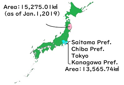
Altogether, Saitama Prefecture, Chiba Prefecture, Kanagawa Prefecture, and Tokyo land areas are equal to 13,565.74 km2. Iwate has a land area of 15,275.01 km2, making it larger than all of Tokyo and its surrounding suburbs!
Latitude and longitude coordinates

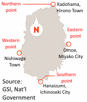
Eastern point: Omoe, Miyako City – 142°4’ E
Western point: Nishiwaga Town, Waga County – 140°39’ E
Southern point: Nagai, Hanaizumi district, Ichinoseki City - 38°44’ N
Northern point: Kadohama, Hirono Town, Kunohe County - 40°27’ N
Iwate's climate
A large portion of Iwate’s inland region is made up of hilly, mountainous terrain, with the Ou mountain range to the west, forming a natural border between Iwate and Akita Prefecture. Parallel to this mountain range is the Kitakami highlands to the east, with the Kitakami river dividing these two hilly regions in the middle. Plains line the basin of this great river.
The coastal regions can be divided into north and south. North of Miyako City lies a distinctive elevated coast, with massive cliffs and marine terraces rising up above the sea. In Tanohata Village lies the Kitayamazaki cliffs, a massive geological structure rising 200 meters and spanning 8 km that is truly a sight to see. On the other hand is the southern coast, with the Kitakami highlands sloping down towards the ocean, creating a remarkable example of a “rias” coast – a jagged coastline dotted with bays and inlets. The waters off the coast form the world-renowned Sanriku fishing environment, and there are many ports and bays on the coast for use by the fishing industry.
Iwate’s unique climate is directly influenced by its geological factors. The regions lining the Ou mountains are a “snow country” just like the regions of Japan facing the Sea of Japan, while the towns and villages in the Kitakami highlands experience weather typical of highland regions, and also moderate-weather typical of basin regions. The plains along the Kitakami river face freezing winter temperatures and a hot summer season typical of inland regions. The coast experiences a typical ocean-area climate, but north of Miyako City, the area tends to face low temperatures and cold-weather damage to agriculture.
| Jan | Feb | Mar | Apr | May | Jun | Jul | Aug | Sep | Oct | Nov | Dec | |
|---|---|---|---|---|---|---|---|---|---|---|---|---|
| Avg. temps (C°) | -1.1 | -0.1 | 3.9 | 8.1 | 16.4 | 18.6 | 22.6 | 25.4 | 20.3 | 14.1 | 5.9 | 1.3 |
| High temps (C°) | 6.1 | 12.1 | 19.0 | 23.3 | 33.6 | 29.7 | 33.4 | 35.9 | 32.6 | 29.2 | 18.5 | 12.2 |
| Low temps (C°) | -9.0 | -8.4 | -5.3 | -3.7 | 2.6 | 8.0 | 13.6 | 16.6 | 8.0 | 1.7 | -5.3 | -7.1 |
| Rainfall (mm) | 20.5 | 48.5 | 52.5 | 89.5 | 111.0 | 134.0 | 58.0 | 113.5 | 57.0 | 206.0 | 70.0 | 69.0 |
| Deepest snow (cm) | 34 | 21 | 42 | 6 | - | - | - | - | - | - | - | 38 |
| Jan | Feb | Mar | Apr | May | Jun | Jul | Aug | Sep | Oct | Nov | Dec | |
|---|---|---|---|---|---|---|---|---|---|---|---|---|
| Avg. temps (C°) | 0.7 | 1.3 | 4.7 | 8.6 | 15.5 | 16.1 | 20.8 | 23.2 | 20.3 | 14.7 | 7.9 | 3.6 |
| High temps (C°) | 10.4 | 14.4 | 19.4 | 25.2 | 30.6 | 31.0 | 35.0 | 35.7 | 33.8 | 25.1 | 21.2 | 16.8 |
| Low temps (C°) | -6.3 | -9.2 | -4.6 | -2.7 | 3.1 | 8.0 | 14.4 | 15.6 | 10.6 | 4.2 | -4.0 | -5.2 |
| Rainfall (mm) | 1.5 | 14.0 | 141.0 | 84.0 | 70.0 | 176.5 | 32.5 | 197.0 | 54.0 | 675.0 | 1.5 | 37.0 |
| Deepest snow (cm) | 2 | 13 | 26 | 7 | - | - | - | - | - | - | - | - |
| Jan | Feb | Mar | Apr | May | Jun | Jul | Aug | Sep | Oct | Nov | Dec | |
|---|---|---|---|---|---|---|---|---|---|---|---|---|
| Avg. temps (C°) | 1.3 | 2.0 | 5.3 | 8.9 | 15.9 | 17.8 | 21.7 | 24.9 | 21.1 | 15.8 | 8.6 | 4.2 |
| High temps (C°) | 9.2 | 13.9 | 17.2 | 22.3 | 34.7 | 28.2 | 35.2 | 35.6 | 33.4 | 28.2 | 20.2 | 15.5 |
| Low temps (C°) | -4.9 | -6.8 | -3.3 | -1.7 | 4.9 | 9.7 | 15.6 | 17.5 | 11.1 | 6.4 | -2.1 | -2.6 |
| Rainfall (mm) | 3.0 | 32.0 | 79.5 | 138.0 | 159.5 | 207.5 | 136.5 | 298.0 | 60.0 | 506.0 | 68.0 | 32.0 |
| Deepest snow (cm) | 7 | 9 | 14 | - | - | - | - | - | - | - | - | - |
Source: Japan Meteorological Agency
このページに関するお問い合わせ
Office of International Affairs, Department of Homeland Promotion
(020-8570) 10-1 Uchimaru, Morioka City, Iwate Prefecture, JAPAN
Phone number:019-629-5765 Facsimile:019-629-5254
You can access our question form here.

